


Get active
11 free walking apps
If you’ve got an iPhone or an Android-based smartphone and enjoy walking, downloading a relevant app could help you get the most from your outings. We've listed 11 free walking apps to get you started.
Published:

Published:
Each of our selection has a different feature to enhance your walks, from social functions that involve your friends to maps that encourage exploration.
1. MapMyWalk GPS for iPhone, Android or Windows

MapMyWalk allows you to see the time spent walking, distance, pace, speed, elevation, and calories burned. When you finish, MapMyWalk allows you to upload and save your workout data and view it both on the app and on the MapMyWalk website. If you can persuade friends to get involved, MapMyWalk’s social feature lets you share routes and encouraging words. You can also load a saved route to use again, or select routes that other MapMyWalk users have done in your area. You can connect with other wearables and apps such as Fitbit, Garmin, Jawbone, and MyFitnessPal, if you use them.
2. Fitbit App Mobile Tracker (No Fitbit Required)
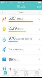
You don’t need to own a Fitbit to use the Fitbit app. The Fitbit app can be used to track your walking workouts with GPS as well as your daily steps using the motion sensor on your phone. After downloading the application, and being prompted to select which tracker you are setting up, choose “no Fitbit yet” and it will set up the Mobile Tracker. Following each workout, you can review your route, distance, time, pace, mile split times, calories burned, and steps. You can also challenge your friends with virtual adventure races, if you feel like a bit of friendly competition.
3. Walkmeter GPS, available for iPhone and Android

Walkmeter has plenty of fun features to try. You can view your walks on a calendar or by route. It links with Google Maps so you can see terrain maps, and it even automatically records the weather. Walkers can transfer maps into the app directly from an email or your web browser, while Race Compete mode lets you compare your own times and speeds along a frequently trodden route. The app includes maps, graphs, training plans, heart rate zones and interval splits, and can be paired with an Apple Watch for a more personalised workout.
4. Footpath Route Planner for iPhone

Footpath allows you to easily map out routes. Simply trace a route with your finger, and Footpath will show all trails and roads that will allow you to complete your walk. It can measure the distance you’ll need to travel and the height you’ll be climbing. It allows you to save and share routes for a later walk, and can work offline too.
5. Go Jauntly for iPhone and Android

Go Jauntly is a walking app that helps people discover over 700 walking routes throughout the UK. They have teamed up Transport for London to encourage city-dwellers to get walking. Information such as walking times to the nearest Tube station, Overground stations and Santander Cycles docking stations is available as well as directions for local walks and station accessibility. But it’s not just London-based: there are walks around the UK. As well as discovering existing routes, users can create their own, add their own photos, and share their creations with others.
6. AlpineQuest Off-Road Explorer, for Android

Another navigation app that's great for exploring off the beaten track, the free (lite) version comes with online maps. If you want to access online maps for offline use, there is also a premium paid-for version of the maps. A useful feature is that you can create multi-layered maps, for example with an aerial photo layered on top of the terrain map. It includes a compass and map orientation function.
7. Nike Run Club for iPhone or Android
Don’t let the name deceive you: this app can be used for walking too. Alongside standard route, time and speed tracking, helpful feature Auto-Pause freezes data collection when you stop moving, so there’s no need to worry about having a sit-down if you need it.
8. OutDoors GPS for iPhone or iPad

Access the full range of Ordnance Survey maps (although be aware that most are priced individually), or use Open Street Map or Google Maps for free. All maps can be stored in your phone – perfect for internet-free rural rambles. You can use the Route Builder function to plan a suitable walk, or import routes for online.
9. ViewRanger, for iOS or Android

Turn your phone or tablet into a GPS unit with this app. You can access free Open Street Maps, or you pay to download Ordnance Survey maps - either as individual maps, or for the whole of the UK. Maps for other countries are available, too.
Use it to record routes as you go, and save waypoints. It will display location, altitude, and grid reference. You can plan routes on its website beforehand using a computer (easier with a larger screen) and then access them on your phone. There's also a BuddyBeacon function which allows you to share your position with others using the app, or see where they are. You can import and export routes too, if you want to share them with others. can
10. World Walking, available for iPhone and Android

Devised by cardiac rehabilitation instructor Duncan Galbraith the World Walking app is a constant pedometer, recording the number of steps you take each day. Users pick legendary global routes, such as Route 66 in the United States or Peru’s Machu Picchu Inca Trail, and try to take enough steps to complete it. The app encourages social interaction too and lets walkers form virtual clubs, working together to meet distance targets.
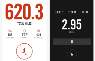
11. Strava, for iPhone and Android

Strava can be used to track more activities than you can shake a stick at, from cycling through to windsurfing, and of course, walking. With the help of GPS it can measure distance, time, elevation gain, calories and route. It's even possible to track your heart rate if you sync the app up with your heart rate monitor.
Not only can you create and share your own walking routes with friends, you can look at heatmaps to see popular routes in your local area. The app also acts as a social network, allowing you to connect with friends and family to share details and photos of your activities.
Find out more
- Read about 7 free running apps
- Read about 7 free fitness apps

